

Acrylic longitude, longitude on plexiglass, plexi longitude
FILTER RESULTS
Image orientation: all
horizontal
vertical
square
Filetype: all
photo
illustration
vector
Apply
#531998084
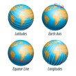
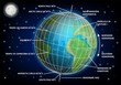
 latitude and longitude diagram of earth
#430459770
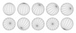
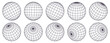 Globe grid spheres. Striped 3D spheres, geometry globe grid, earth latitude and longitude line grid...
#144094978
 Set spheres globe earth grid, latitude longitude
#55931208
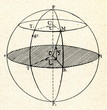 Latitude and longitude of point M
#290062458
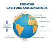 Equator latitude or longitude vector illustration. Equator line explanation
#638883859
 Vector map of the world with countries and a grid in the projection for a scale of 110 m.
#116683759
 Latitude and longitude of the earth globe vector illustration
#503866452
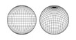
 3d globe grid, planet sphere and ball wireframe. Vector Earth globe surface with discrete global...
#444029918
 Schematic illustration of globe with latitude and longitude lines on a black background
#723436866
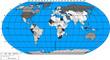
 Blue Map of the World With Country Borders and Oceans
#171177096
 Glowing Globe with Wire frame latitude and longitude lines, part Photo part Illustration: Blue...
#594876519
 Globe grid spheres. Striped 3D spheres, geometry globe grid, earth latitude and longitude line grid...
#694520215
 Latitude longitude lines grid, earth mapping . Geographic coordinate system. World prime meridian...
#126932915
 Point and curve constructed the sphere wireframe, technological sense abstract illustration.
#464698390
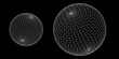
 Set of 3d vector spheres from different sides. Horizontal and vertical lines, latitude and longitude
#314034108
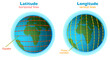
 Latitude and longitude diagram, vector educational poster
#220929565
 Map scales graphics for measuring distances. Scale measure map vector. Latitude and longitude...
#760680138
 Topographic map patterns, topography line map. Vintage outdoors style. The black on white contours...
#501419059
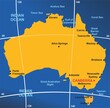 Australia map infographic diagram with all surrounding oceans seas gulf capital and main cities...
#564607289
 Vector world map. Hammer projection. Plain world geographical map with latitude and longitude lines....
#553360623
 Topographic map background geographic line map with elevation assignments. Modern design with White...
#517123459
 The world with most important circles of latitudes and longitudes, gray political map. Equator,...
#299048970
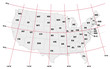 administrative map United States with latitude and longitude
#742686715
 Abstract topographic contours 3d map background .topographic line texture background .monochrome...
#564223821
 3D sphere wireframe icon in brutalism style. Orbit model, spherical shape, grid ball. Earth globe...
#619445831
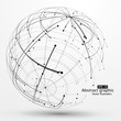
 3D wireframe globe or sphere on black background, visualization of geography or navigation concept...
#480707290
 The magnifying glass is located on the world map and magnifies the country of USA. There's a compass...
#715632899
 Compass icon set illustration. arrow compass icon sign and symbol
#622740682
 earth grid outline icon in white and black colors. earth grid flat vector icon from delivery and...
#755598081
 A compass is on top of a map
#603766011
 3D Isometric Flat Vector Conceptual Illustration of Latitude And Longitude Diagram, Geographic...
#33500411
 Old map and navigational objects.
add to favorites