

gulf of mexico on dibond, aluminum dibond gulf of mexico, gulf of mexico dibond plate, gulf of mexico on aluminium
FILTER RESULTS
Image orientation: all
horizontal
vertical
square
Filetype: all
photo
illustration
vector
Apply
#276554373
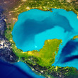
 Detailed Earth at night. Mexico
#243448215
 Mexican gulf map
#78717872
 Oil spill at Mississippi delta, captured from space.
#288193843
 sunset over the Gulf of Mexico
#437146828
 Sunrise at Cypremort Point, Louisiana, USA
#416188183
 Oil Rig Sunset
#462939535
 Jackup moveable oil platform at sunset in Gulf of Mexico
#3522951
 beach chairs and umbrella
#515256656
 Offshore Drilling Platform in the Gulf of Mexico with Copy Space
#193960927
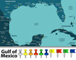 Gulf of Mexico map
#281328627
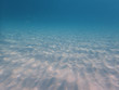 Underwater photo of artistic sand lines.
#330101532
 Sunset over Gulf of Mexico from Caspersen Beach in Venice Florida
#53525706
 Boardwalk in the Beach Sand Dunes
#71352675
 Oil platform silhouette, gulf of Mexico
#530180901
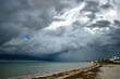 Tropical storm, hurricane over the Gulf of Mexico, black clouds over the ocean, Caribbean Sea
#50050217
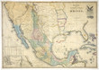 Mexico old map
#228460753
 gulf of mexico road vector map
#443389174
 Ecological crisis. Swampy polluted river water
#163817135
 Drilling platform during the coming storm
#277721628
 Turquoise water and blue sea in Siesta Key beach
#272309335
 Detailed Earth. Gulf of Mexico and Florida
#352784962
 Galveston Island historic Pleasure Pier on the Gulf of Mexico coast in Texas.
#430120373
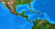 Physical map of Central America and the Caribbean. Detailed flat view of the Planet Earth and its...
#300245426
 Wave on Beach at Sunset
#1610400
 oil rigs at sunset
#237187758
 Holmes Beach
#245300849
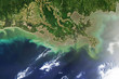
 Distribution pattern of muddy fresh water from the Mississippi River as it flows into the Gulf of...
#320692668
 Aerial landscape view of Captiva Island and Sanibel Island in Lee County, Florida, United States
#510934624
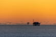 Offshore Drilling Platforms during Sunset in the Gulf of Mexico
#222490571
 Long wooden fishing docks stretch out into Galveston Bay, Texas
#773909443
 The skeleton of a whale lies at the bottom of the sea
#331088187
 Gulf of Mexico beach at Sanibel Island Lighthouse Beach Park on Sanibel Island Florida
add to favorites